A clearer view of danger
Originally published by Jamaica Observer Read the original
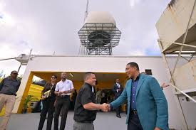
AFTER years of mechanical setbacks and prolonged interruptions that left Jamaica’s weather monitoring capabilities compromised, the country stepped into a new era of weather forecasting with a fully upgraded Doppler radar system, now operational and promising sharper insight into developing storms, heavier rainfall, and other potentially dangerous weather conditions.
At a cost of US$2.45 million, the Defender S850 Doppler Weather Radar was procured in 2020 under the Improving Climate Data and Information Management Project, with funds from the World Bank through the Climate Investment Fund. Located at Cooper’s Hill in St Andrew, it is expected to significantly strengthen the island’s ability to track weather systems, identify the nature and movement of precipitation, and provide meteorologists with more detailed information to improve forecasts and warnings.
According to Meteorological Service of Jamaica Principal Director Evan Thompson, the system should have initially been commissioned in 2022, following its installation in 2021, but was delayed due to mechanical failure.
“Testing and integration of the radar into the operations of the National Meteorological Centre ensued until the first quarter of 2022 when arrangements were being made for its commissioning on World Meteorological Day 2022. A mechanical failure, however, within the physical infrastructure forced a disruption of the service on March 9, two weeks before the commissioning was supposed to take place, and the radar remained offline through to late 2024,” Thompson told guests at the Radar Commissioning Ceremony and Hurricane Melissa commemorative book launch at the site last Wednesday.
“The rebuilding process resumed in September 2024 and was completed in June of 2025, shortly after the start of the hurricane season. This was timely, of course, in preparation for the development and the passage of Hurricane Melissa. The radar, however, experienced another disruption of service in November of 2025, shortly after the passage of Melissa, and this was not restored until March of this year, with partial functionality. But the comprehensive, full functionality of the radar was completed in September of 2026,” Thompson explained.
Experts describe the Defender S850 Doppler Weather Radar as a stateof- the-art, S-Band, meteorological system manufactured by Enterprise Electronics Corporation. It is engineered specifically for long-range severe weather detection, tracking, and early warning capabilities.
“The range of the radar is 480 kilometres, so it only goes as far as western Haiti; it doesn’t go that far east,” Thompson told the Jamaica Observer when asked whether the technology could detect and analyse weather systems from the time they move off the west coast of Africa, where most atmospheric disturbances that travel towards the Caribbean during the hurricane season originate.
The radar, he added, provides close monitoring over and immediately around Jamaica. He said the Defender S850 is an upgrade from that which was first installed in 1999 — the WSR-88D, which was the first of its kind in the Englishspeaking Caribbean. “It is an upgrade...it has further features, including what we call dual polarisation, so it allows for us to distinguish better between the different things that it is sensing — whether it may be rainfall or hail, or it might be dust particles that it is picking up. It helps us to distinguish better what is it we are identifying from the radar. There are some other features, but it is an upgrade to what we had,” he said.
According to Thompson, the new system is included in the Caribbean Meteorological Organisation (CMO) radar mosaic. “There are a number of radars operating, coordinated by the CMO, so they are operating throughout the region in different countries. Each radar is represented on a website so we are able to track systems moving right through the Caribbean. All of them together — if you show the radar imagery of the Caribbean — you could track systems from one radar to the next, so it allows for us to create that mosaic of all the radars so we can see them all represented in one picture,” Thompson explained.
“Now that we have our radar and it is fully operational, we have included it into that mosaic, so it fills the gap between the Dominican Republic and the Cayman Islands,” he added.
Thompson told the ceremony that the system has undergone several upgrades since its installation in 1999, but the recent upgrade marks a significant milestone for weather forecasting in Jamaica.
“The radar served well through many severe weather systems, including, of course, Hurricane Ivan in 2004, but eventually it experienced many downtimes from ageing parts, with those instances becoming more and more frequent. The time had come during the latter part of the decade to have it totally modernised or replaced. In 2016 the Government launched the Improving Climate Data and Information Management Project (ICDIMP), implemented by the PIOJ [Planning Institute of Jamaica], and this was a project amounting to a cost of about US$6.8 million, but almost half of that went to the radar. That was about US$3 million for a new S-band radar that was part of the project. This current radar was installed as part of that ICDIMP,” he said, adding that the radar station also benefited from the installation of a solar power solution to reduce energy costs, and a water-harvesting solution to ensure consistent provision of water.
The newly installed Defender S850 Doppler radar system was prioritised by the Government to strengthen Jamaica’s preparedness for increasingly intense storms.
In October 2025, as Hurricane Melissa bore down on Jamaica, real-time radar data gave meteorologists a critical, up-to-the-minute picture of the storm’s speed, path, and intensifying strength. The intelligence proved vital, allowing authorities to get ahead of the threat by directing evacuations, mobilising emergency services, and opening shelters before the monster storm made landfall.
“This investment made a major difference. It’s the first time in about seven years that Jamaica was able to rely on some of its own data capacity to forecast what was going to happen,” said Minister of Water, Environment and Climate Change Matthew Samuda.
“For 10 days before the storm actually made landfall the Met Service was able to warn Jamaicans that this was coming without having to solely depend on the National Hurricane Center in Florida — and that makes a massive difference when we’re able to give our citizens early warning,” he added.
Last week, Thompson explained that radar technology gives forecasters lead time, “especially for flash floods on Jamaica’s short-switched rivers that satellite alone cannot give”.
“The radar is essential to our early warning system in Jamaica, facilitating real-time monitoring of precipitation over and around the country, determination of speed and direction of movement of rainfall cells, providing the data for short-term forecasting of severe weather systems, verifying the output of automatic weather stations and manual rain gauges through ground truthing, and being a valuable contributor to scientific evaluation and research,” he said.
Last Wednesday’s ceremony was also used to launch the Hurricane Melissa commemorative book, produced by the Meteorological Service and the Ministry of Water, Environment and Climate Change.
Samuda noted that the book serves as an important documentation for what the country went through, and will be available islandwide.
“It is the Hurricane Melissa – The Jamaican Chronicle.
This knowledge product is not technologically displayed here this afternoon but is important to document the work that the Met Service and, indeed, ODPEM [Office of Disaster Preparedness and Emergency Management] would have had to do pre- and post-Hurricane Melissa,” Samuda said.
“When I got assigned to this portfolio I asked for mountains and mountains of documents as we tried to learn the portfolio. Some of the things I asked about was, ‘Where was the chronicle post-Ivan?’ It wasn’t there. There are academic studies on Hurricane Gilbert, but nothing produced by us. So, the Government is documenting the incredibly destructive event so that future generations are, indeed, able to study, learn how we prepared, learn how we recovered,” Samuda said.